'%3e%3cpath%20d='M39.45%202.007v8.24c0%20.853-.684%201.493-1.495%201.493h-8.367a1.485%201.485%200%200%201-1.494-1.494V1.922c0-.854.683-1.494%201.494-1.494h8.239c.896-.043%201.622.683%201.622%201.58Z'%20fill='url(%23b)'/%3e%3cpath%20d='M39.45%202.007v8.24c0%20.853-.684%201.493-1.495%201.493h-8.367a1.485%201.485%200%200%201-1.494-1.494V1.922c0-.854.683-1.494%201.494-1.494h8.239c.896-.043%201.622.683%201.622%201.58Z'%20fill='%23212121'/%3e%3cpath%20d='M6.66%2013.32h2.305a4.39%204.39%200%200%201%204.397%204.396v4.568a4.345%204.345%200%200%201-4.355%204.354H6.702C2.988%2026.681%200%2029.67%200%2033.34A6.668%206.668%200%200%200%206.66%2040a6.668%206.668%200%200%200%206.66-6.66v-2.305a4.345%204.345%200%200%201%204.353-4.354h4.568a4.345%204.345%200%200%201%204.355%204.354v2.305a6.668%206.668%200%200%200%206.66%206.66%206.668%206.668%200%200%200%206.659-6.66%206.668%206.668%200%200%200-6.66-6.66H30.95a4.39%204.39%200%200%201-4.397-4.396V19.04a5.72%205.72%200%200%200-5.72-5.72h-3.245a4.39%204.39%200%200%201-4.397-4.398V6.617C13.319%202.988%2010.373%200%206.66%200A6.668%206.668%200%200%200%200%206.66a6.668%206.668%200%200%200%206.66%206.66Z'%20fill='url(%23c)'/%3e%3cpath%20d='M6.66%2013.32h2.305a4.39%204.39%200%200%201%204.397%204.396v4.568a4.345%204.345%200%200%201-4.355%204.354H6.702C2.988%2026.681%200%2029.67%200%2033.34A6.668%206.668%200%200%200%206.66%2040a6.668%206.668%200%200%200%206.66-6.66v-2.305a4.345%204.345%200%200%201%204.353-4.354h4.568a4.345%204.345%200%200%201%204.355%204.354v2.305a6.668%206.668%200%200%200%206.66%206.66%206.668%206.668%200%200%200%206.659-6.66%206.668%206.668%200%200%200-6.66-6.66H30.95a4.39%204.39%200%200%201-4.397-4.396V19.04a5.72%205.72%200%200%200-5.72-5.72h-3.245a4.39%204.39%200%200%201-4.397-4.398V6.617C13.319%202.988%2010.373%200%206.66%200A6.668%206.668%200%200%200%200%206.66a6.668%206.668%200%200%200%206.66%206.66Z'%20fill='%23212121'/%3e%3c/g%3e%3cdefs%3e%3cpattern%20id='b'%20patternContentUnits='objectBoundingBox'%20width='1'%20height='1'%3e%3cuse%20xlink:href='%23d'%20transform='translate(-.247)%20scale(.00083)'/%3e%3c/pattern%3e%3cpattern%20id='c'%20patternContentUnits='objectBoundingBox'%20width='1'%20height='1'%3e%3cuse%20xlink:href='%23d'%20transform='matrix(.00084%200%200%20.00083%20-.251%200)'/%3e%3c/pattern%3e%3cclipPath%20id='a'%3e%3cpath%20fill='%23fff'%20d='M0%200h40v40H0z'/%3e%3c/clipPath%3e%3c/defs%3e%3c/svg%3e)
Transforming Construction Management: Understanding The Differences Among Survey Tools for The Digital Era
Surveying, a core element of construction and project management, has seen significant changes with the introduction of advanced tools like laser scanners, cloud point cameras, and drones. Surveying technology has advanced over recent years, offering various tools to capture accurate spatial data.
Among the most prominent are laser scanners, point cloud cameras, and drones. Each of these technologies has unique features and applications that make them suitable for different types of projects. Understanding their differences is key to choosing the right tool for your surveying needs.
Laser Scanners
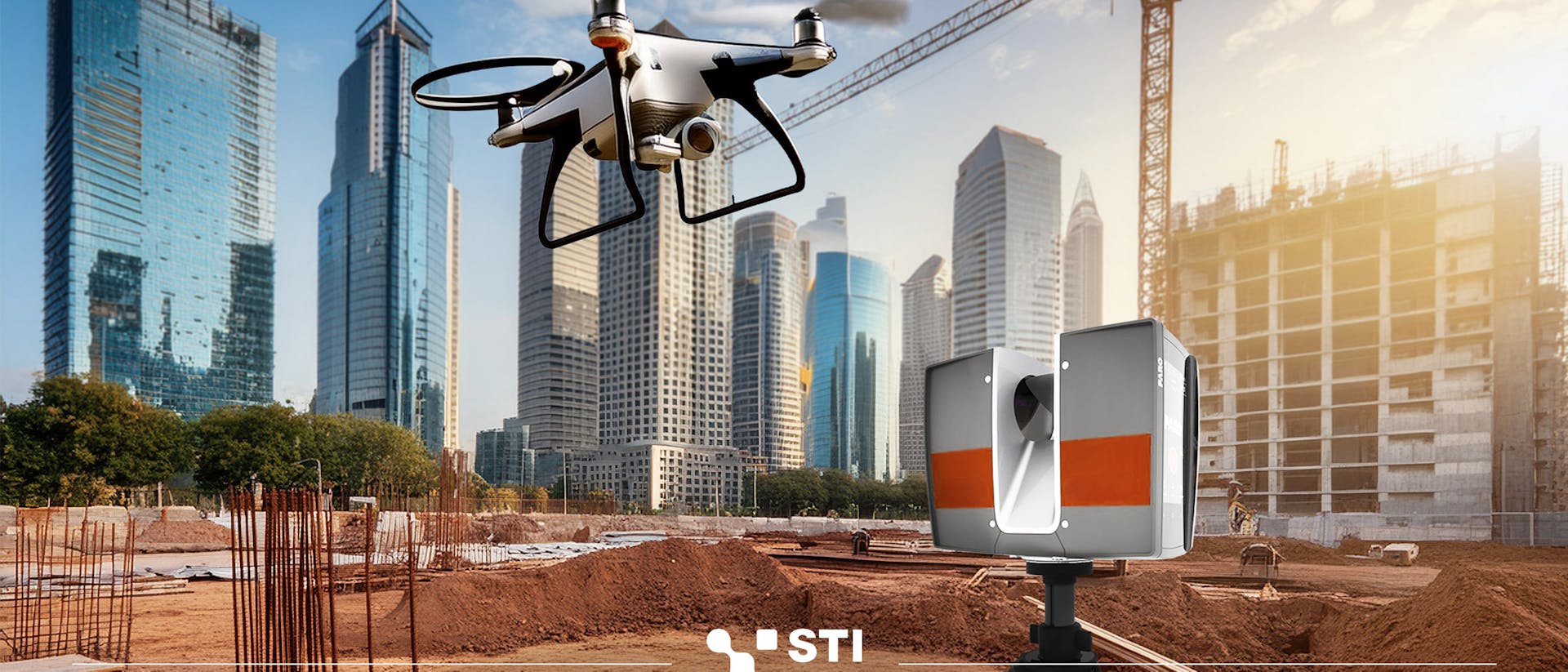
Laser scanners use laser beams to measure distances to a target. By emitting a laser pulse and measuring the time it takes for the reflection to return, these devices can create highly accurate 3D models of structures and environments. This technology, often referred to as LiDAR (Light Detection and Ranging), is renowned for its precision and ability to capture fine details. Laser scanners are ideal for applications in architecture, construction, and industrial inspection. They are particularly effective in complex environments.
Another key benefit of laser scanners is their compatibility with Building Information Modeling (BIM) software. The detailed 3D models generated by laser scanning technology can be seamlessly integrated into BIM workflows, facilitating clash detection, as-built surveys, and construction planning. This integration enhances collaboration among project stakeholders and enables better decision-making throughout the project lifecycle.
Point Cloud Cameras
Point cloud cameras, often part of photogrammetry systems, generate 3D models by capturing a series of photographs from different angles. These images are then processed using software to create a detailed point cloud, which accurately represent the geometry of objects and surfaces.
Point cloud cameras are generally more accessible and easier to use than laser scanners. These cameras require minimal training to operate and can be deployed quickly on construction sites, making them accessible to a wide range of construction professionals.
They are highly effective in capturing surface details and textures, making them suitable for applications in architecture, archaeology, cultural heritage preservation, and any scenario where visual detail is paramount. They offer visual clarity, allowing project teams to conduct virtual site visits, monitor progress providing documentation and analysis throughout the project lifecycle, and identify potential issues with greater accuracy.
However, they may not offer the same level of precision as laser scanners, particularly in large-scale or highly detailed projects. To solve this problem, in recent years some cameras are equipped with LiDAR sensors to enhance the output, providing more accurate and detailed data. This makes them useful in construction and other fields requiring precise measurements.
Drones
Drones, or unmanned aerial vehicles (UAVs), have revolutionized surveying by offering aerial perspectives and real-time data acquisition even in places that would be inaccessible or impractical for traditional surveying methods. They are equipped with cameras or LiDAR systems, as well as different types of sensors and lights, providing a versatile platform for surveying, so they are capable of producing both photogrammetric and LiDAR point clouds, depending on the sensors they carry. Additionally, terrestrial drones (ground-based drones) equipped with various sensors can navigate through challenging terrains to collect data in environments where aerial drones may not be effective.
The key advantage of drones is their ability to gather data from aerial or terrestrial perspectives, which is invaluable for large-scale surveys, covering large areas efficiently. They can reach tunnels or sections that are difficult or dangerously reachable by an operator. However, their effectiveness can be limited by weather conditions, regulatory restrictions, and the requirement for skilled operators.
Conclusion
Choosing the right surveying technology depends on the specific requirements of your project. Laser scanners offer unparalleled precision and are best for detailed and complex environments. Point cloud cameras provide detailed surface textures and are more accessible for smaller-scale projects, with the option to enhance accuracy by integrating LiDAR sensors. Drones, both aerial and terrestrial, offer extensive coverage and versatile perspectives, making them ideal for large and hard-to-reach areas.
By understanding these differences, you can select the most appropriate tool to achieve accurate and efficient survey results and improve project planning and execution. These modern tools not only improve precision and speed, but they also transform the approach to planning, executing, and monitoring construction projects. With the prompt and precise data from survey tools, project teams can spot problems early, reduce risks, and make sure the project stays on schedule and meets quality specifications, providing valuable insights into site conditions, progress, and logistics.
At STI Digital, we go beyond providing survey tools; we create a comprehensive digital ecosystem designed to help construction firms excel in today's construction management landscape. We harness the power of survey technology and digital innovation to help these firms optimize workflows, improve collaboration, and deliver superior project outcomes. With STI Digital as their partner, construction firms can look forward to the future of construction management with confidence, unlocking unprecedented levels of safety, efficiency, productivity, and achievement.
Contact us for more information